Breaking news! Alta Vista Transportation Corridor will not cut through OOE People’s Park
Shawn Menard, our Capital Ward Councillor, is happy to announce that the field beside 170 Lees venue known as “the People’s Park” is no longer being considered for a freeway.
In the most recently updated draft of the city’s new Transportation Master Plan (TMP), City staff are recommending that the portion of the Alta Vista Transportation Corridor (AVTC) route that was supposed to pass over the Rideau River and through People’s Park beside Lees Apartments be removed.
- See page 10 excerpt of the TMP Capital Infrastructure Plan Highlights report at the end of this post.
The councillor noted the importance of community engagement on this process. “This has been a really important issue for the residents of Old Ottawa East, and for the people who come from across the city to enjoy the park,” continued Menard.
With its proximity to the Lees LRT Station, and transit service along Lees Avenue and Main Street, there was no longer a need for a freeway through the community. “Certainly, there are better uses for this field than a roadway,” he said.
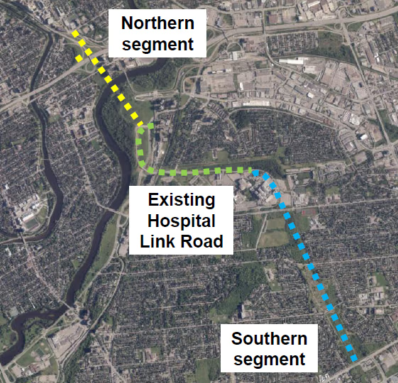
The existing Hospital Link Road – green dotted line – loops from Alta Vista to Riverside Drive south of Hurdman.
The southern segment – blue dotted line (Conroy Road to Hospital Link Road) – remains in the plan.
The northern segment – yellow dotted line (Hurdman to the 417 Queensway) – is recommended to be removed.
- Read the full press release and background information on the AVTC at ShawnMenard.ca.
- Visit Engage Ottawa Transportation Master Plan (TMP) for the latest news, including April dates for TMP Phase 5 public consultations.
Highlights of TMP Infrastructure Plan – Alta Vista Transportation Corridor (AVTC)
Source: TMP Capital Infrastructure Plan Highlights Report (page 10)
The TMP Capital Infrastructure Plan reviewed the need and justification for additional road and/or transit infrastructure within different segments of the Alta Vista Transportation Corridor (AVTC).
The AVTC extends from the intersection of Walkley Road and Conroy Road in southeast Ottawa, north through the Alta Vista community to the Smyth Road Hospital Complex, crosses the Rideau River and connects to Nicholas Street at the Highway 417 Interchange. A transportation facility has been proposed in this corridor since at least 1950.
Based on the updated TMP analysis, the recommendations for the AVTC are as follows:
- Northern Section (Hospital Link Road to Nicholas Street/Highway 417 On-ramps): Remove the northern section of the AVTC from the TMP Needs-Based Road Network, and from the Ultimate Road Network in the Official Plan. Travel demand modelling for the TMP indicates that a road connection within this segment would provide no effective congestion relief, primarily due to downstream capacity constraints.
- Southern Section (Walkley Road to Hospital Link Road): Maintain this segment of the AVTC within the TMP Needs-Based Road Network, and retain the designation of the AVTC from Walkley Road to the Southeast Transitway as a Transit Priority Corridor. Travel demand modelling for the TMP indicates that a road connection within this segment of the AVTC would reduce pressure on Alta Vista Drive and St.
Exhibit 1: Alta Vista Transportation Corridor 10 Laurent Boulevard, improve connectivity, and provide direct transit access from Conroy Road to the Southeast Transitway.